


Ash Hollow
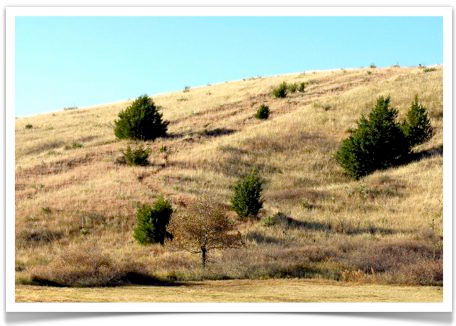
ABOVE: The hill at Ash Hollow. In this modern-day photo, you can still see the ruts left by the covered wagons. (Starting at the upper right and moving to the lower left)
Most emigrants had been following the south side of the Platte River for hundreds of miles--this was the best place to cross. Unlike many other crossings, this river crossing was was not difficult most years. That’s because the Platte here was often no more than one or two feet deep--although it was typically more than a mile wide. Some years, the Platte River would actually be two miles wide at this point.
 The reason for the crossing was simple: for hundreds of miles, the pioneers had followed the south side of the Platte River, but the river was about to split in two. If they stayed on the south side of the river (now the South Platte), the pioneers would have reached a dead end in Colorado. So they had to cross the river to connect with the north branch--called the North Platte.
A few miles further along the trail was Ash Hollow. Here was fresh, clean water--a luxury the emigrants had not tasted for weeks. But getting to Ash Hollow was tricky. The pioneers had to negotiate a very steep hill. Sometimes they would let the wagons down with ropes--or get a dozen men to hold on as "human brakes." Occasionally, the brakesmen would lose control of a wagon and a severe crash would result.
Once they reached the bottom, Ash Hollow was a welcome site. The trees were the first the pioneers had seen for 100 miles. Most of the wagon trains would rest at Ash Hollow for a day or two.
Emigrant E. B. Farnham:
"This is the best looking place we have seen for some time. It is a cool shady looking place fragrant with different kinds of flowers of which rose and jasmine are the principle. Grape vines and currant bushes are plenteous."
Captain Howard Stansbury:
"Several springs of delightfully cold and refreshing water were found, altogether the best that has been met with since leaving Missouri."